Before we started to study space, things seemed fine. But then space exploration came and evolved, and nowadays, satellite data is part of our daily activity even if we don’t recognise it. From reliable internet connection and constant weather monitoring to national defense, those little spacecraft circling the planet are our irreplaceable helpers, though we may not realise the full magnitude of their contribution to human life on Earth. Let’s see how satellite cameras work for our benefit every single moment.
How Does the Use of Satellites Change Life on Earth?
The simple answer is immense. Modern satellite cameras provide us with the opportunity to observe the planet in a way we were never capable of before. Other than imagery, satellites serve us to improve significantly:
Communication: The whole world is connected now; even rural areas that were impossible to reach several decades ago can enjoy a fast and reliable internet connection.
Agriculture and farming: Gathering and analysing satellite images provide experts with information that can be used to monitor and better crops as well as make the use of resources more rational.
Environment: Strongly connected with the previous point, satellite observation helps climate experts work on sustainable solutions for our planet that suffers the consequences of our previously irresponsible behaviour.
Navigation: This is one of the benefits of satellites that regular people use every day. With satellite camera view and constantly updating data, we are able to reach the point of destination quickly and safely. GPS even warns if there’s traffic ahead! Indeed, our life is more convenient in this regard now.
Those points are far from the exhaustive list of benefits we have now, thanks to a small satellite camera located in orbit.
How Has Satellite Imaging Changed the Way We See the World?
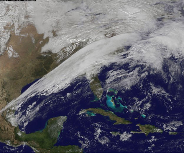
Satellite photography has made a great difference in the way we look at the Earth these days. It is a game changer as it provides never experienced before level of accuracy and enables to observe and understand geographical features, environmental changes and human activities in very high detail.
Through capturing high-resolution images of the earth’s surface from space, satellite imaging has helped us to understand various phenomena, such as urban development, deforestation, climate change, natural disasters, agriculture patterns, and more. This technology confers inestimable benefits upon scientists, politicians, corporations and individuals in the form of data for decision-making, planning, resource management, environmental conservation, and effective disaster response.
The accessibility of satellite imagery has increased, as the satellite camera price tends to get lower with years of development. However, improved access to detailed images of the planet at any given time also raises some privacy concerns. So, do the benefits outweigh the downfalls?
Is Taking a Satellite Camera Image a Violation of People’s Privacy?

Some privacy concerns related to satellite imagery are understandable. Satellite cameras capable of capturing high-resolution images can potentially compromise privacy by capturing detailed images of homes, buildings, and even people. To address these concerns, regulations, and policies are in place to limit the resolution of images available to the public.
However, it’s essential to maintain a balance between the benefits of satellite technology for various sectors and the protection of individual privacy. Governments and satellite imagery providers often have guidelines and restrictions in place to minimize potential privacy infringements while leveraging the advantages of satellite imaging for various purposes.
Still, the information satellite cameras are capable of obtaining is mostly available through public registers or even through browsing a regular person’s social media.
While privacy concerns should not be underestimated, the overall benefits of using satellite images for humankind’s well-being surely outweigh them.
Scientific Research And Exploration
Satellite imaging cameras also have an unmatched influence on sciences and discoveries. Starting from mapping the surface of the exoplanets to learning the influence of climate change in the Earth, satellites give the scientific community an enormous amount of data and knowledge about the natural world.
As an illustration, the satellites fitted with specific cameras and sensors can detect environmental factors such as temperature, humidity, soil moisture and the ocean currents enabling scientists to follow the change of climate and ecological dynamics in the Earth.
Further, satellite imagery has been a major player in disaster management, being a critical tool in monitoring natural calamities including (but not limited to) earthquakes, volcanic eruptions, and wildfires, that pave the way for optimal disaster response and recovery measures.
Final Words
So, how do satellite images help people on Earth? Will we notice if they are not there anymore? The answer is we sure will, and we won’t like it. From taking a better route through a crowded city, talking to loved ones with a real-time video connection, receiving precise weather forecasts every morning on our smartphones, and making sure the next generations won’t suffer from the lack of food, satellites make it all possible daily. This new level of globalization may be disturbing for some, but it’s important to keep in mind the huge benefits satellite utilization brings to our lives.


